Marengo Watershed Hydrologic Restoration
Restoring headwater streams and wetlands to reduce flooding
What does it take to restore headwater streams and wetlands to reduce flooding, erosion, and culvert failures downstream? How much funding and coordination is necessary, and what are the barriers? In 2020, the Ashland County Land and Water Conservation Department (LWCD) designed the Act 157 Marengo River Natural Flood Management project to answer these questions.
The Marengo River Watershed was chosen due to the availability of repetitive-loss culvert and road-stream crossing data, stream hazard vulnerability information, frequently reoccurring large floods, and major soil erosion events. The combination of steep terrain, erodible soils, historic and current hydrologic alterations, and multiple severe storms led to repetitive flood damage to road-stream crossings and farmlands. Numerous private landowners in the watershed have been adversely affected by these problems, and many are interested in cooperating with the LWCD to find solutions. The Marengo River is a tributary of the Bad River, which flows into Lake Superior.
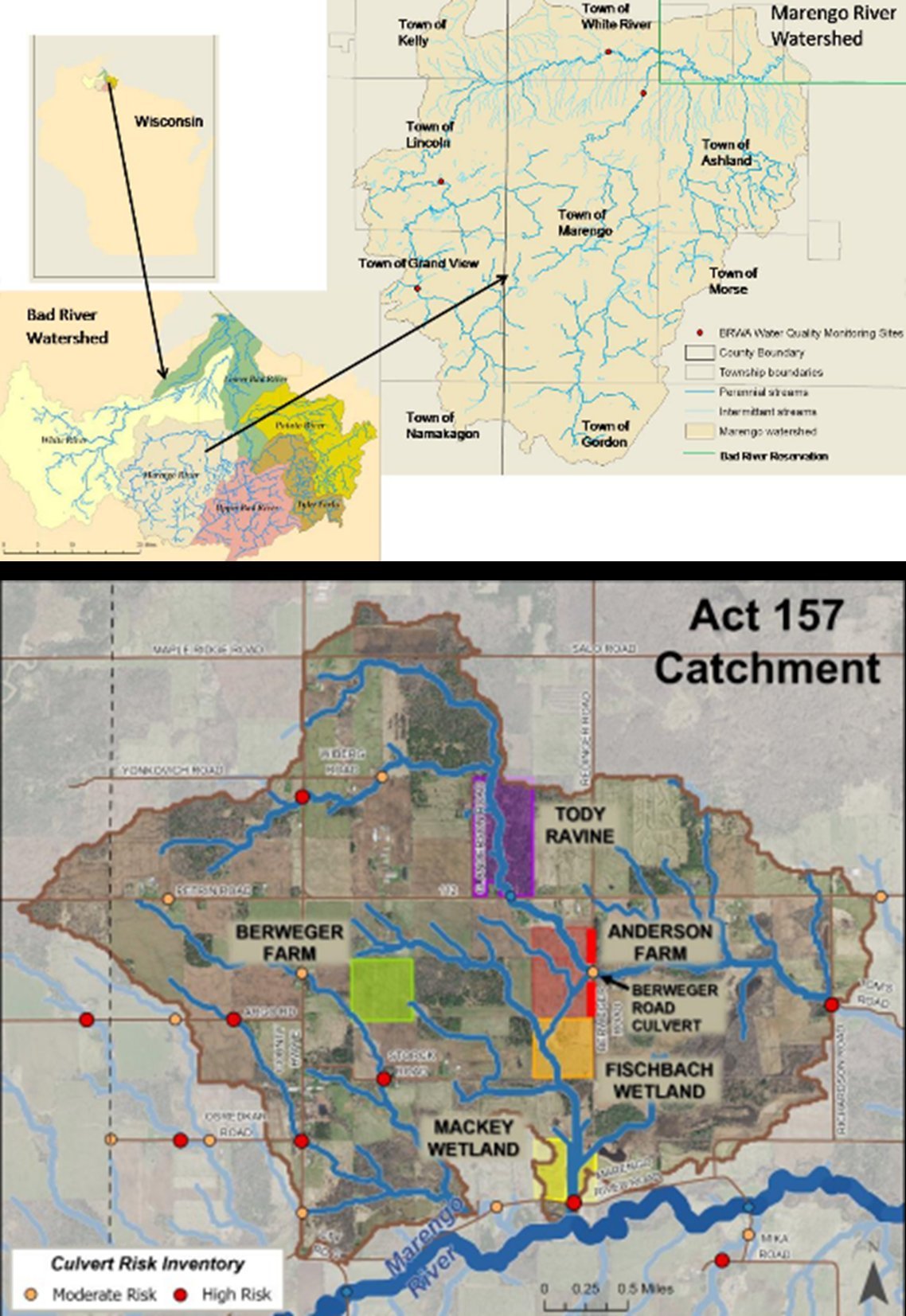
Act 157 Catchment area project sites.
Planning for Act 157 required the specialized expertise of multiple government agencies and technical contractors. It also relied on existing data sets and hydrologic models for the Marengo Watershed. Understanding and predicting where water will flow and how it will behave after high rainfall events is a complex undertaking! However, these predictions are essential to prioritize where and what restoration practices will be most effective and efficient. Ashland County LWCD was awarded funds from the WI Legislature through Act 157, and several state and federal grants. They assembled a skilled design team that included professionals and affected landowners, and developed plans for hydrological restorations at five properties within the watershed.
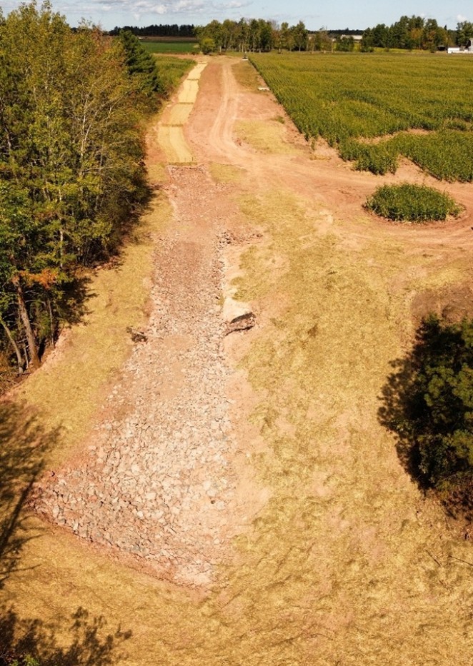
After years of conceptual planning, strict permitting, and design, implementation began at the first site in 2023. A combination of low-tech and traditional engineering practices was selected to 'slow the flow' of water by dissipating energy and connecting waterways back to their floodplains. At the Tody Ravine, eleven channel-spanning structures known as post-assisted log structures (PALS) and two Newberry Rock Riffles were installed to slow water and deposit sediment to promote the rising of the streambed elevation to reconnect the stream to its adjacent floodplain. At the Berweger Farm, severe gully erosion was restored through a wetland restoration, grassed waterway, rock Zuni Bowl, and a rock-lined channel. Downstream, at the Fischbach Wetland, a 10-acre wet site, was restored via wetland scrapes, a berm, and a rock spillway.
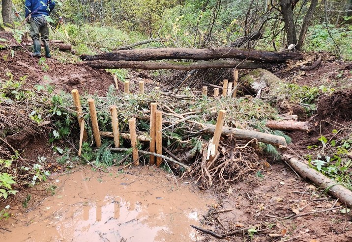
Tody Ravine: Post-Assisted Log Structures.
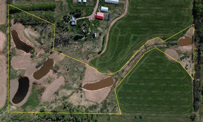
Wetland Scrapes Capture Runoff to "Slow-the-Flow."
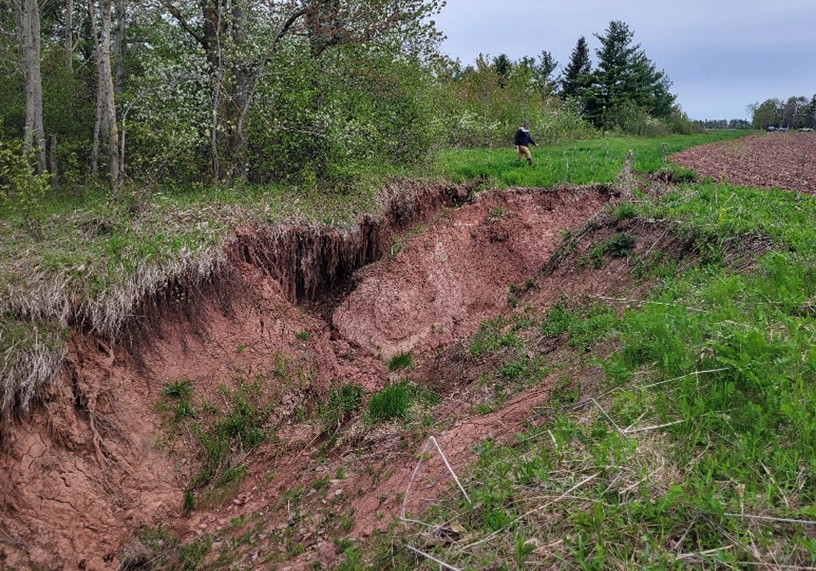
Berweger Farm: Head-cutting & Extreme Gullying.
Berweger Farm: Drone Photo of Final Project.
Permitting and regulatory barriers arose at two sites. These prohibited the projects from being implemented. The Anderson Farm & Berweger Road Culvert design included installing a larger culvert, restoring the stream to a two-stage channel, and stabilizing gullies and road ditches. The site is in a FEMA-mapped Zone AE floodplain, which added costly and time-consuming regulatory requirements that Ashland County did not have the resources to address. These rendered the project unviable within the budget and grant timeframe. This was disappointing because the FEMA maps were outdated, and there were administrative barriers to using more recent and accurate data. In fact, Ashland County could not find a contractor willing to take on the work due to past experiences of delays and project uncertainties when working in FEMA-regulated floodplains. The result is continuing non-point pollution, water quality impairment, high flood risk, and productive farmland continues to erode.
Regulatory barriers to management also developed at the Mackey Wetland. This site was identified as critical for hydrologic restoration because the large wetland is located at the bottom of the catchment, where the capacity to manage and store flood flows is essential. An embankment that sustained the wetland and protected the Marengo River Road from flooding was breached during the 2016 flood. It will likely fail in a future high rainfall event. As with the Anderson Farm & Berweger Culvert project, the Mackey site also lies within a Zone AE floodplain. As such, it is subject to the same costly and time-consuming regulatory requirements. In addition, the fix was interpreted as meeting the definition of a "dam" for regulatory purposes and would likely be denied a permit under current rules. Again, no action has been taken here to mitigate future habitat degradation and flood risk.
What Did We Learn?
The project highlighted the need for a shared vision among conservation partners to reap catchment-scale benefits. On the positive side, multiple agencies, led by Ashland County LWCD, worked together to successfully implement a variety of 'low-tech' solutions that can be implemented in the headwaters to reduce downstream flooding. Implementing hydrologic restoration at a catchment scale can leverage funding and amplify benefits but it also increases complexity. The project team needed to manage a higher volume of programs, grants, and regulatory coordination, uncovering a need for more planning and administrative resources for such large-scale efforts.
On the negative side, lower in the watershed, regulatory barriers were encountered when federal rules required additional modeling and permitting that was beyond the capacity and hydrologic modeling expertise of the partners. These rules may be necessary when dealing with the higher energy and more destructive potential of higher-order streams. However, more damage will be done if regulations prevent positive actions to mitigate flood risks.
What Are the Solutions?
- Sustain and increase funding for nature-based solutions to reduce flood risks. Funding agencies should incorporate timelines with more flexibility to meet additional regulatory requirements, if needed.
- The state should invest in baseline data and technical staff skilled in hydrologic & hydraulic modeling to support watershed-scale restorations, including vulnerability assessments and engineering design.
- Develop streamlined approaches for multi-agency coordination on complex hydrologic restoration projects.
- Review current regulatory requirements that affect watershed restorations and update policies regarding the intensity and cost of pre-planning.
- Update the FEMA maps. Federal agencies should keep these maps updated to reflect current conditions in the watershed.
- If restoration work in higher-order streams and their floodplains requires more intensive planning and engineering to meet regulatory requirements, the federal government should provide the technical expertise and underwrite the cost of this additional work in a timely manner. Delays increase the risk of catastrophic failure of key infrastructure.